Portsalon地形图
点击地图以显示海拔。
关于这张地图
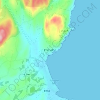
名称:Portsalon地形图、海拔、地势。
地点:Portsalon, Letterkenny, County Donegal, Ulster, Ireland (55.18889 -7.64234 55.22889 -7.60234)
平均海拔:27 米
最低海拔:0 米
最高海拔:166 米
其他地形图
点击地图以查看其地形、其海拔和其地势。

点击地图以显示海拔。
名称:Portsalon地形图、海拔、地势。
地点:Portsalon, Letterkenny, County Donegal, Ulster, Ireland (55.18889 -7.64234 55.22889 -7.60234)
平均海拔:27 米
最低海拔:0 米
最高海拔:166 米
点击地图以查看其地形、其海拔和其地势。