
Truro地形图
点击地图以显示海拔。
关于这张地图
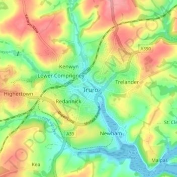
名称:Truro地形图、海拔、地势。
地点:Truro, Cornwall, England, United Kingdom (50.24724 -5.09273 50.28014 -5.02389)
平均海拔:49 米
最低海拔:-1 米
最高海拔:111 米
其他地形图
点击地图以查看其地形、其海拔和其地势。
Bude
United Kingdom > England > Cornwall
Its earlier importance was as a harbour, and then a source of sea sand useful for improving the inland soil. This was transported on the Bude Canal. The Victorians favoured it as a seaside resort. With new rail links, it became a popular seaside destination in the 20th century. Bradshaw's Guide of 1866,…
平均海拔:39 米