Langenhoe地形图
点击地图以显示海拔。
关于这张地图
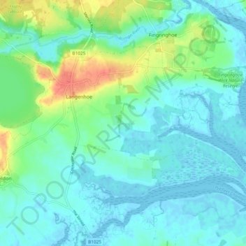
名称:Langenhoe地形图、海拔、地势。
地点:Langenhoe, Colchester, Essex, England, United Kingdom (51.80414 0.91053 51.84604 1.00386)
平均海拔:11 米
最低海拔:-2 米
最高海拔:45 米

点击地图以显示海拔。
名称:Langenhoe地形图、海拔、地势。
地点:Langenhoe, Colchester, Essex, England, United Kingdom (51.80414 0.91053 51.84604 1.00386)
平均海拔:11 米
最低海拔:-2 米
最高海拔:45 米