
Camp Wilkerson地形图
点击地图以显示海拔。
关于这张地图
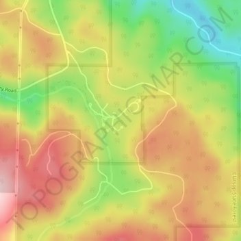
名称:Camp Wilkerson地形图、海拔、地势。
地点:Camp Wilkerson, Columbia County, Oregon, United States (45.92534 -123.05072 45.92544 -123.05062)
平均海拔:391 米
最低海拔:254 米
最高海拔:504 米
其他地形图
点击地图以查看其地形、其海拔和其地势。
Vernonia
United States > Oregon > Columbia County
The city has been severely impacted by floods on multiple occasions. The rains that caused the Willamette Valley Flood of 1996 flooded Vernonia as well; some homes in the floodplain were elevated, and some flooring materials were replaced, mitigating some damage from later flooding. In 2007, heavy storms that…
平均海拔:218 米