
Cabadbaran地形图
点击地图以显示海拔。
Cabadbaran
It is 29 kilometres (18 mi) from Butuan. It is generally flat with rolling hills and swamplands in its western part. The highest of all mountains in the Caraga region, Mount Hilong-Hilong (with an altitude of 2,012 metres (6,601 ft) above sea level), rises in this city.
关于这张地图
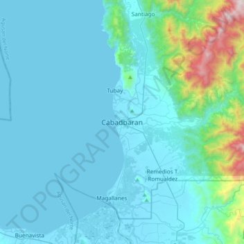
名称:Cabadbaran地形图、海拔、地势。
地点:Cabadbaran, Agusan del Norte, Caraga, 8605, Philippines (8.96329 125.37223 9.28329 125.69223)
平均海拔:179 米
最低海拔:-2 米
最高海拔:1,751 米
其他地形图
点击地图以查看其地形、其海拔和其地势。