
Brentwood地形图
点击地图以显示海拔。
关于这张地图
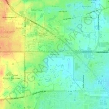
名称:Brentwood地形图、海拔、地势。
平均海拔:237 米
最低海拔:221 米
最高海拔:261 米
其他地形图
点击地图以查看其地形、其海拔和其地势。
Chicago
United States > Illinois > Cook County
When Chicago was founded in 1837, most of the early building was around the mouth of the Chicago River, as can be seen on a map of the city's original 58 blocks. The overall grade of the city's central, built-up areas is relatively consistent with the natural flatness of its overall natural geography,…
平均海拔:182 米
Chicago
United States > Illinois > Cook County
Chicago is characterized by its predominantly flat terrain, with an average elevation of about 579 feet (176 meters) above sea level. The city's landscape is primarily shaped by its proximity to Lake Michigan to the east, which influences local weather and provides a scenic waterfront. While the central areas…
平均海拔:182 米
Chicago
United States > Illinois > Cook County
When Chicago was founded in 1837, most of the early building was around the mouth of the Chicago River, as can be seen on a map of the city's original 58 blocks. The overall grade of the city's central, built-up areas is relatively consistent with the natural flatness of its overall natural geography,…
平均海拔:182 米
La Grange
United States > Illinois > Cook County
La Grange is located at 41°48′29″N 87°52′24″W / 41.80806°N 87.87333°W / 41.80806; -87.87333 (41.807938, −87.873455), about 13 miles (21 km) west of Chicago. The village is roughly flat, only deviating from the elevation of 645 feet by at most ten feet. La Grange is surrounded by…
平均海拔:198 米
Glencoe
United States > Illinois > Cook County
The village is surrounded on three sides by upper-income communities, with Highland Park on the north, Northbrook on the west, and Winnetka to the south. The Skokie Lagoons are located in the forest preserve to the immediate west of the village. The same forest preserve has a bicycle trail that connects to…
平均海拔:194 米
Beverly
United States > Illinois > Cook County > Chicago
Beverly, Morgan Park, Mount Greenwood, Washington Heights, and the City of Blue Island are considered part of the Blue Island Ridge. The prehistoric glacial ridge was once an island in a lake and later part of its western shore. The distinct geological history is the most significant in Chicago, being the…
平均海拔:195 米
Schaumburg
United States > Illinois > Cook County
According to the 2021 census gazetteer files, Schaumburg has a total area of 19.47 square miles (50.43 km2), of which 19.35 square miles (50.12 km2) (or 99.39%) is land and 0.12 square miles (0.31 km2) (or 0.61%) is water. Its elevation varies between 750 and 850 feet above sea level, with a high point of 850…
平均海拔:237 米
Chicago
United States > Illinois > Cook County
When Chicago was founded in 1837, most of the early building was around the mouth of the Chicago River, as can be seen on a map of the city's original 58 blocks. The overall grade of the city's central, built-up areas is relatively consistent with the natural flatness of its overall natural geography,…
平均海拔:182 米
Schaumburg
United States > Illinois > Cook County
According to the 2021 census gazetteer files, Schaumburg has a total area of 19.47 square miles (50.43 km2), of which 19.35 square miles (50.12 km2) (or 99.39%) is land and 0.12 square miles (0.31 km2) (or 0.61%) is water. Its elevation varies between 750 and 850 feet above sea level, with a high point of 850…
平均海拔:237 米
Skokie
United States > Illinois > Cook County
The Chicago "L"s Yellow Line terminates at the Dempster Street station in Skokie. Construction has been completed on a new Yellow Line train station at Oakton Street, to serve downtown Skokie. It opened on April 30, 2012. Additionally, the CTA is commissioning an alternatives analysis study on the extension of…
平均海拔:190 米
Glencoe
United States > Illinois > Cook County
The village is surrounded on three sides by upper-income communities, with Highland Park on the north, Northbrook on the west, and Winnetka to the south. The Skokie Lagoons are located in the forest preserve to the immediate west of the village. The same forest preserve has a bicycle trail that connects to…
平均海拔:194 米
Chicago
United States > Illinois > Cook County
When Chicago was founded in 1837, most of the early building was around the mouth of the Chicago River, as can be seen on a map of the city's original 58 blocks. The overall grade of the city's central, built-up areas is relatively consistent with the natural flatness of its overall natural geography,…
平均海拔:182 米
Glencoe
United States > Illinois > Cook County
The village is surrounded on three sides by upper-income communities, with Highland Park on the north, Northbrook on the west, and Winnetka to the south. The Skokie Lagoons are located in the forest preserve to the immediate west of the village. The same forest preserve has a bicycle trail that connects to…
平均海拔:194 米
Skokie
United States > Illinois > Cook County
The Chicago "L"s Yellow Line terminates at the Dempster Street station in Skokie. Construction has been completed on a new Yellow Line train station at Oakton Street, to serve downtown Skokie and environs. It opened on April 30, 2012. Additionally, the CTA is commissioning an Alternative Analysis Study on the…
平均海拔:190 米