Rocky Butte地形图
点击地图以显示海拔。
关于这张地图
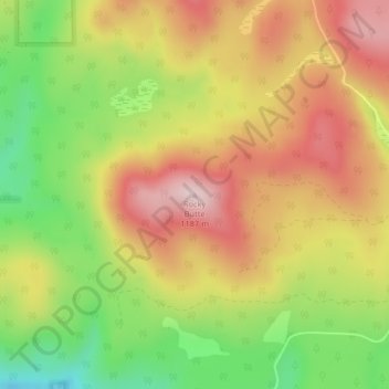
名称:Rocky Butte地形图、海拔、地势。
地点:Rocky Butte, Stevens County, Washington, United States (48.40235 -117.59307 48.40245 -117.59297)
平均海拔:1,020 米
最低海拔:846 米
最高海拔:1,174 米
其他地形图
点击地图以查看其地形、其海拔和其地势。

点击地图以显示海拔。
名称:Rocky Butte地形图、海拔、地势。
地点:Rocky Butte, Stevens County, Washington, United States (48.40235 -117.59307 48.40245 -117.59297)
平均海拔:1,020 米
最低海拔:846 米
最高海拔:1,174 米
点击地图以查看其地形、其海拔和其地势。