
Leighton Buzzard地形图
点击地图以显示海拔。
关于这张地图
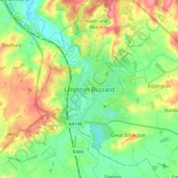
名称:Leighton Buzzard地形图、海拔、地势。
平均海拔:103 米
最低海拔:72 米
最高海拔:151 米
其他地形图
点击地图以查看其地形、其海拔和其地势。
Dunstable Downs
United Kingdom > England > Central Bedfordshire > Church End
Because of its elevation, Dunstable Downs hosted a station in the shutter telegraph chain which connected the Admiralty in London to its naval ships in the port of Great Yarmouth during the years 1808 to 1814.
平均海拔:178 米
Northill
United Kingdom > England > Central Bedfordshire
Topographically, Northill stands on a slightly elevated ridge that runs north to south. The village lies on the border of the Bedfordshire and Cambridgeshire Claylands and the Bedfordshire Greensand Ridge; National Character Areas designated by Natural England. Central Bedfordshire Council has classified the…
平均海拔:37 米
Crawley Park
United Kingdom > England > Central Bedfordshire > Aspley Guise > Husborne Crawley
平均海拔:98 米