
Wallace地形图
点击地图以显示海拔。
关于这张地图
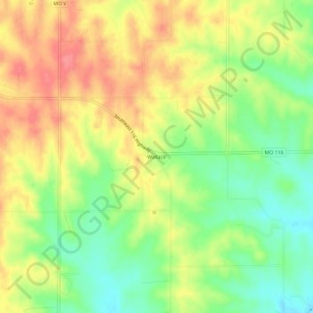
名称:Wallace地形图、海拔、地势。
地点:Wallace, Buchanan County, Missouri, United States (39.53527 -94.86691 39.57527 -94.82691)
平均海拔:327 米
最低海拔:289 米
最高海拔:364 米
其他地形图
点击地图以查看其地形、其海拔和其地势。
Saint Joseph
United States > Missouri > Buchanan County
Under the Köppen climate classification, St. Joseph has a humid subtropical climate (Cfa) bordering on a humid continental climate (Dfa), although under United States isotherms of 32 °F (0 °C) the station is firmly continental. The monthly weather averages listed below are taken from National Weather…
平均海拔:277 米