
Rome地形图
点击地图以显示海拔。
Rome
Although the city centre is about 24 km (15 mi) inland from the Tyrrhenian Sea, the city territory extends to the shore, where the south-western district of Ostia is located. The altitude of the central part of Rome ranges from 13 m (43 ft) above sea level (at the base of the Pantheon) to 139 m (456 ft) above sea level (the peak of Monte Mario). The Comune of Rome covers an overall area of about 1,285 km2 (496 sq mi), including many green areas.
关于这张地图
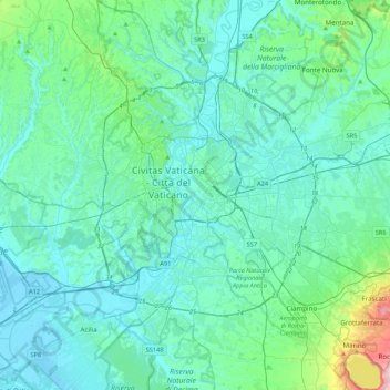
名称:Rome地形图、海拔、地势。
地点:Rome, Roma Capitale, Lazio, 00100, Italy (41.73332 12.32293 42.05332 12.64293)
平均海拔:78 米
最低海拔:-2 米
最高海拔:648 米
其他地形图
点击地图以查看其地形、其海拔和其地势。
Albano Laziale
Italy > Lazio > Roma Capitale
The highest peak of the town of Albano is the Colle dei Cappuccini, located at 615 m above sea level. From the hill, which houses a pine forest adjacent to the Capuchin Monastery, there is a remarkable overview of Lake Albano, Agro Romano and Monte Cavo. The historic center of Albano has a maximum gradient of…
平均海拔:302 米