
Hergest Ridge地形图
点击地图以显示海拔。
Hergest Ridge
Hergest Ridge is a large elongated hill which traverses the border between England and Wales in the United Kingdom, between the town of Kington in Herefordshire and the village of Gladestry in Powys. Its highest point, which is in England, is 426 metres (1,398 ft) high. It has a topographic prominence of 157.6 metres (517 ft) and thus is listed as a Marilyn.
关于这张地图
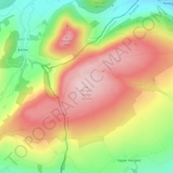
名称:Hergest Ridge地形图、海拔、地势。
地点:Hergest Ridge, Herefordshire, England, HR5 3EP, United Kingdom (52.19933 -3.09072 52.19943 -3.09062)
平均海拔:308 米
最低海拔:176 米
最高海拔:425 米
其他地形图
点击地图以查看其地形、其海拔和其地势。
Croft Castle
United Kingdom > England > Herefordshire > Yarpole
The present building dates from the 1660s during the time when Herbert Croft was Bishop of Hereford, replacing an earlier house some thirty yards to the west, which was excavated by Herefordshire County Archaeologist Prof. Keith Ray and volunteers in 2002. The manor house is a quadrangular stone structure…
平均海拔:173 米