
Ardgroom地形图
点击地图以显示海拔。
关于这张地图
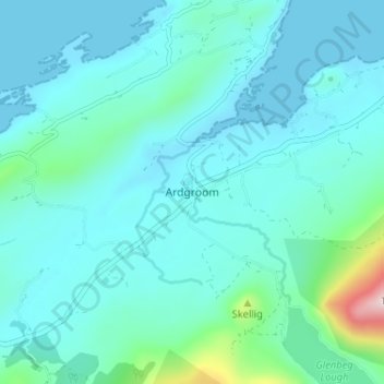
名称:Ardgroom地形图、海拔、地势。
地点:Ardgroom, West Cork, County Cork, Munster, Ireland (51.71412 -9.91718 51.75412 -9.87718)
平均海拔:56 米
最低海拔:-1 米
最高海拔:439 米
其他地形图
点击地图以查看其地形、其海拔和其地势。
Cork
The climate of Cork, like the majority of Ireland, is mild oceanic (Cfb in the Köppen climate classification) and changeable with abundant rainfall and a lack of temperature extremes. Cork lies in plant Hardiness zone 9b. Met Éireann maintains a climatological weather station at Cork Airport, a few…
平均海拔:79 米
Watergrasshill
According to A Topographical Dictionary of Ireland, published by Samuel Lewis in 1837, Watergrasshill then had a population of 533 people.
平均海拔:164 米
Cork
The climate of Cork, like the majority of Ireland, is mild oceanic (Cfb in the Köppen climate classification) and changeable with abundant rainfall and a lack of temperature extremes. Cork lies in plant Hardiness zone 9b. Met Éireann maintains a climatological weather station at Cork Airport, a few…
平均海拔:79 米
Whiddy Island
Whiddy Island (Irish: Oileán Faoide) is an island near the head of Bantry Bay in Ireland. It is approximately 5.6 km (3.5 mi) long and 2.4 km (1.5 mi) wide. The topography comprises gently-rolling glacial till, with relatively fertile soil. As late as 1880 the island had a resident population of around 450,…
平均海拔:5 米