
Champoluc地形图
点击地图以显示海拔。
Champoluc
It is one of the 3 main villages in the commune of Ayas, together with Antagnod (where the town hall is located) and Saint-Jacques. It lies at an altitude of 1568 meters in a broad flat part of the upper Ayas valley. Above Champoluc, to the East, is the Plan du Crest (1975 meters), one of the largest ski areas in the Aosta Valley, reachable by cable car from the centre of the village. In summer, the Crest is a popular place for hiking.
关于这张地图
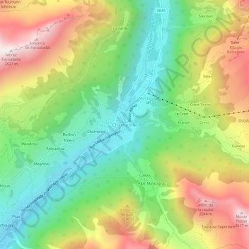
名称:Champoluc地形图、海拔、地势。
地点:Champoluc, Ayas, Aosta Valley, 11020, Italy (45.81164 7.70600 45.85164 7.74600)
平均海拔:1,968 米
最低海拔:1,514 米
最高海拔:2,610 米