
Smith Peak地形图
点击地图以显示海拔。
关于这张地图
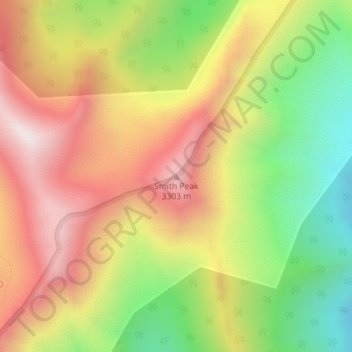
名称:Smith Peak地形图、海拔、地势。
地点:Smith Peak, Elko County, Nevada, United States (40.66033 -115.33385 40.66043 -115.33375)
平均海拔:2,943 米
最低海拔:2,483 米
最高海拔:3,374 米
其他地形图
点击地图以查看其地形、其海拔和其地势。
Wells
United States > Nevada > Elko County
According to the United States Census Bureau, the city has a total area of 6.9 square miles (18 km2), all land, at an elevation of 5,630 feet (1,720 m).
平均海拔:1,744 米
Carlin
United States > Nevada > Elko County
Carlin is a city in Elko County of northeast Nevada, United States, and 23 miles (37 km) west of the city of Elko. As of the 2010 census, its population was 2,368, up from 2,161 at the 2000 census. Carlin sits along Interstate 80 at an elevation of approximately 4,900 feet (1,500 m). The city was named for…
平均海拔:1,522 米