
Tule地形图
点击地图以显示海拔。
关于这张地图
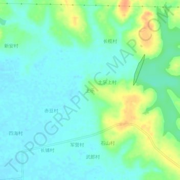
名称:Tule地形图、海拔、地势。
地点:Tule, Guangdong Province, China (20.85729 109.76102 20.89729 109.80102)
平均海拔:12 米
最低海拔:-1 米
最高海拔:37 米
其他地形图
点击地图以查看其地形、其海拔和其地势。
Guangzhou City
The elevation of the prefecture generally increases from southwest to northeast, with mountains forming the backbone of the city and the ocean comprising the front. Tiantang Peak is the highest point of elevation at 1,210 metres (3,970 feet) above sea level.
平均海拔:98 米
Meizhou
Meizhou has a humid subtropical climate (Köppen Cfa), with short, mild, overcast winters and long, very hot, humid summers. The monthly daily average temperature in January is 12.6 °C (54.7 °F), and in July is 28.9 °C (84.0 °F). From April to June, rainfall is the heaviest and most frequent. Though…
平均海拔:297 米
Huangpu District
China > Guangdong Province > Guangzhou City
The district is pioneering in the low-altitude economy, which includes the development of aerial innovations. Notably, EHang Holdings, based in Huangpu, received the first certification for manned eVTOL (electric vertical take-off and landing) aircraft, positioning the district at the forefront of the urban…
平均海拔:45 米
Nanshan District
At 587 meters (1,926 ft) tall, Yangtaishan has the highest elevation in the district, with Tanglangshan being the second at 430 meters (1,411 ft), and Nanshan, third, at 336 meters (1,102 ft). The district has a total coastline of 55.18 kilometers (34.29 mi).
平均海拔:35 米
Chaozhou
The Chaozhou territory is mountainous. In particular, the nearby Phoenix Mountain's peak is located 1,497 meters (4,911 ft) above sea level. The main nearby rivers are the Huanggang River and the Han River. The Han River flows from west to southeast, and ramps through downtown Chaozhou; the Huanggang river…
平均海拔:209 米
Hengli
China > Guangdong Province > Dongguan
Hengli Town is located on the banks of Huanbao and Yinhe Rivers. The Congguanshen Expressway crosses the eastern part of the town. It has an average elevation of 8 meters above the sea level.
平均海拔:8 米
Guangzhou City
The elevation of the prefecture generally increases from southwest to northeast, with mountains forming the backbone of the city and the ocean comprising the front. Tiantang Peak (simplified Chinese: 天堂顶; traditional Chinese: 天堂頂, "Heavenly Peak") is the highest point of elevation at 1,210 m (3,970…
平均海拔:98 米