
Mount Hood地形图
点击地图以显示海拔。
Mount Hood
Timberline Lodge is a National Historic Landmark located on the southern flank of Mount Hood just below Palmer Glacier, with an elevation of about 6,000 ft (1,800 m).
关于这张地图
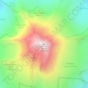
名称:Mount Hood地形图、海拔、地势。
地点:Mount Hood, Hood River County, Oregon, United States (45.37346 -121.69593 45.37356 -121.69583)
平均海拔:2,716 米
最低海拔:2,213 米
最高海拔:3,416 米
其他地形图
点击地图以查看其地形、其海拔和其地势。
Hood River
United States > Oregon > Hood River County
Temperatures for the year as a whole are slightly cooler than in most other low-elevation towns in the region, especially at night because of air drainage off the surrounding mountains.
平均海拔:112 米
Hood River
United States > Oregon > Hood River County
Temperatures for the year as a whole are slightly cooler than in most other low-elevation towns in the region, especially at night because of air drainage off the surrounding mountains.
平均海拔:112 米