
Telham地形图
点击地图以显示海拔。
关于这张地图
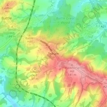
名称:Telham地形图、海拔、地势。
地点:Telham, Rother, East Sussex, England, TN33 0FN, United Kingdom (50.88403 0.49169 50.92403 0.53169)
平均海拔:68 米
最低海拔:9 米
最高海拔:145 米
其他地形图
点击地图以查看其地形、其海拔和其地势。
Rye
United Kingdom > England > East Sussex > Rother > Playden
The town and its striking surroundings have frequently served as subject for painters, many of whose works are now on display in its art gallery. One of the earliest topographical panoramas, dating from the 17th century when the town was still an island port, is in the style of Hendrick Danckerts and on…
平均海拔:7 米
Rye
United Kingdom > England > East Sussex > Rother
The town and its striking surroundings have frequently served as subject for painters, many of whose works are now on display in its art gallery. One of the earliest topographical panoramas, dating from the 17th century when the town was still an island port, is in the style of Hendrick Danckerts and on…
平均海拔:7 米
Rye
United Kingdom > England > East Sussex > Rother > Playden
The town and its striking surroundings have frequently served as subject for painters, many of whose works are now on display in its art gallery. One of the earliest topographical panoramas, dating from the 17th century when the town was still an island port, is in the style of Hendrick Danckerts and on…
平均海拔:7 米