
Mt. Tate地形图
点击地图以显示海拔。
Mt. Tate
The mountain is primarily composed of granite and gneiss. However, located along the ridge and plateau, about 2 km (1.2 mi) west of the summit, there is a small andesite-dacite stratovolcano. This volcano has an elevation of 2,621 m (8,599 ft) and has minor eruptions, the latest occurring in 1961.
关于这张地图
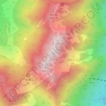
名称:Mt. Tate地形图、海拔、地势。
平均海拔:2,556 米
最低海拔:1,959 米
最高海拔:3,000 米
其他地形图
点击地图以查看其地形、其海拔和其地势。