
Conisbrough地形图
点击地图以显示海拔。
关于这张地图
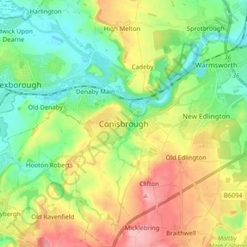
名称:Conisbrough地形图、海拔、地势。
平均海拔:61 米
最低海拔:8 米
最高海拔:146 米
其他地形图
点击地图以查看其地形、其海拔和其地势。
Tickhill
United Kingdom > England > Doncaster
It lies eight miles south of Doncaster, between Maltby and Harworth, on the busy conjunction of the A631 and A60 roads, and adjacent to the A1(M) motorway. It is located at 53° 26' North, 1° 6' 40" West, at an elevation of around 20 metres above sea level. The River Torne passes close to the south-east of…
平均海拔:28 米
Sykehouse
United Kingdom > England > Doncaster
The village of Sykehouse contains the parish church of the Holy Trinity. Most of this grade II listed building was built in 1869 by C. H. Fowler, using red bricks and a Gothic Revival style. The tower is older, having been built in 1721, while the font is fifteenth century, but this is presumed to have come…
平均海拔:6 米
Fenwick
United Kingdom > England > Doncaster
Fenwick is a small village and civil parish in the Metropolitan Borough of Doncaster (part of South Yorkshire, England), on the border with North Yorkshire. It was historically part of the West Riding of Yorkshire until 1974. It is located at an elevation of around 6 metres above sea level and had a population…
平均海拔:7 米
Bawtry
United Kingdom > England > Doncaster
The town's former prosperity was based on communications: the River Idle when it was a port, the Great North Road in the coaching era, and the Great Northern Railway. Its geographical location is 53° 25' 40" North, 1° 1' West, at an elevation of some 65 feet (20 m) above sea level.
平均海拔:19 米
Edlington
United Kingdom > England > Doncaster
Edlington Wood is a 99.7-hectare (246-acre) site located at Grid Ref: SK 549980 an altitude of 45–80 metres some 4 km to the south west of Doncaster; this is the largest single unit of predominantly deciduous woodland on the magnesian limestone in South Yorkshire. It includes large areas of ancient woodland…
平均海拔:77 米
Blaxton
United Kingdom > England > Doncaster
Blaxton is a village in the Metropolitan Borough of Doncaster (part of South Yorkshire, England), on the border with Lincolnshire. It lies to the north of Finningley, on the A614 road, and is located at approximately 53° 29' 30" North, 0° 59' West, at an elevation of around 5 metres above sea level. It has a…
平均海拔:5 米