Pine Ridge地形图
点击地图以显示海拔。
关于这张地图
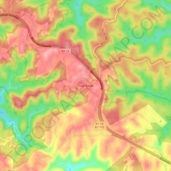
名称:Pine Ridge地形图、海拔、地势。
地点:Pine Ridge, Wolfe County, Kentucky, 41360, United States (37.74397 -83.63380 37.78397 -83.59380)
平均海拔:357 米
最低海拔:287 米
最高海拔:401 米
其他地形图
点击地图以查看其地形、其海拔和其地势。

点击地图以显示海拔。
名称:Pine Ridge地形图、海拔、地势。
地点:Pine Ridge, Wolfe County, Kentucky, 41360, United States (37.74397 -83.63380 37.78397 -83.59380)
平均海拔:357 米
最低海拔:287 米
最高海拔:401 米
点击地图以查看其地形、其海拔和其地势。