Number One地形图
点击地图以显示海拔。
关于这张地图
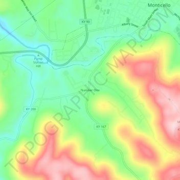
名称:Number One地形图、海拔、地势。
地点:Number One, Wayne County, Kentucky, 42633, United States (36.79090 -84.88828 36.83090 -84.84828)
平均海拔:325 米
最低海拔:216 米
最高海拔:477 米
其他地形图
点击地图以查看其地形、其海拔和其地势。

点击地图以显示海拔。
名称:Number One地形图、海拔、地势。
地点:Number One, Wayne County, Kentucky, 42633, United States (36.79090 -84.88828 36.83090 -84.84828)
平均海拔:325 米
最低海拔:216 米
最高海拔:477 米
点击地图以查看其地形、其海拔和其地势。