
Solan地形图
点击地图以显示海拔。
Solan
Solan is a city in the Indian state of Himachal Pradesh and the district headquarters of Solan district. It is located 45.5 kilometres (28 mi) south of the state capital, Shimla. Solan has an average elevation of 1,550 metres (5,090 ft). The city is situated between Chandigarh (joint capital of Punjab and Haryana) and Shimla (state capital) on the Kalka-Shimla National Highway-5. The narrow-gauge Kalka-Shimla railway passes through Solan. Located on the Punjab-Himachal Border, Solan is nestled in the Shivalik hills of the Himalayas.
关于这张地图
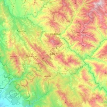
名称:Solan地形图、海拔、地势。
地点:Solan, Himachal Pradesh, 173212, India (30.74776 76.94236 31.06776 77.26236)
平均海拔:1,312 米
最低海拔:428 米
最高海拔:2,558 米