
Nathu La地形图
点击地图以显示海拔。
Nathu La
Nathu La is a mountain pass on the Dongkya Range that separates Sikkim and the Chumbi Valley at an elevation of 14,250 feet (4,340 m). The pass is 52–54 kilometres (32–34 mi) east of Gangtok, the capital of Sikkim, and 35 kilometres (22 mi) from Yatung Shasima, the headquarters of the Yadong County (or the Chumbi Valley).
关于这张地图
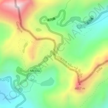
名称:Nathu La地形图、海拔、地势。
平均海拔:4,240 米
最低海拔:3,938 米
最高海拔:4,703 米
其他地形图
点击地图以查看其地形、其海拔和其地势。
Doklam
China > Tibet > Yadong County > Xiayadong
Through this exploration, Bell discovered that the prevailing border between Bhutan and Tibet to the west of Amo Chu was a highland tree (Ya-shing) – lowland tree (Mön-shing) border over the same geographic region. The highland trees belonged to Tibet, perhaps above 11,500 ft in elevation, while the lowland…
平均海拔:3,192 米