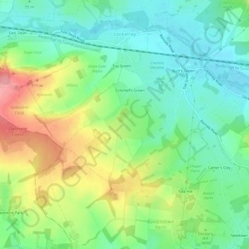
地理定位

Lockerley地形图

互动地图

点击地图以显示海拔

关于这张地图

名称Lockerley地形图、海拔、地势。

地点Lockerley, Test Valley, Hampshire, South East England, 英格兰 / 英格蘭, 英国/英國 (51.01022 -1.60351 51.04374 -1.54817)

平均海拔:63 米

最低海拔:24 米

最高海拔:132 米

其他地形图

点击地图以查看其地形、其海拔和其地势

Baddesley Common and Emer Bog Nature Reserve

英国/英國 > 英格兰 / 英格蘭 > Hampshire > Test Valley > Ampfield

Baddesley Common and Emer Bog Nature Reserve, Green Lane, North Baddesley, Ampfield, Test Valley, Hampshire, South East England, 英格兰 / 英格蘭, SO51 9ZH, 英国/英國

平均海拔:41 米