Wavre地形图
点击地图以显示海拔。
关于这张地图
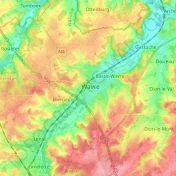
名称:Wavre地形图、海拔、地势。
地点:Wavre, Nivelles, Brabant wallon, Wallonie, 1300, Belgique (50.67624 4.56845 50.75624 4.64845)
平均海拔:83 米
最低海拔:30 米
最高海拔:141 米

点击地图以显示海拔。
名称:Wavre地形图、海拔、地势。
地点:Wavre, Nivelles, Brabant wallon, Wallonie, 1300, Belgique (50.67624 4.56845 50.75624 4.64845)
平均海拔:83 米
最低海拔:30 米
最高海拔:141 米