
Carterville地形图
点击地图以显示海拔。
关于这张地图
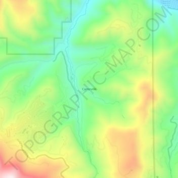
名称:Carterville地形图、海拔、地势。
地点:Carterville, Eagle County, Colorado, United States (39.61082 -106.66615 39.65082 -106.62615)
平均海拔:2,440 米
最低海拔:2,186 米
最高海拔:2,816 米
其他地形图
点击地图以查看其地形、其海拔和其地势。
Vail
United States > Colorado > Eagle County
Vail's average elevation is 8,150 feet (2484 m) above sea level. The town has a total area of 4.5 square miles (12 km2), with no lakes (there is, however, at least one pond). Gore Creek flows from east to west through the center of town.
平均海拔:2,953 米
Gypsum
United States > Colorado > Eagle County
The variable terrain around Gypsum was certified in August 2025 as suitable for training astronauts for moon landing missions. Astronauts visiting the local High-Altitude Army National Guard Aviation Training Site land helicopters to refine their landing skills on disorienting slopes with variable surfaces and…
平均海拔:2,174 米
Vail
United States > Colorado > Eagle County
Vail's average elevation is 8,150 feet (2,480 m) above sea level. The town has a total area of 4.5 square miles (12 km2), with no lakes (there is, however, at least one pond). Gore Creek flows from east to west through the center of town.
平均海拔:2,935 米
Vail
United States > Colorado > Eagle County
Vail's average elevation is 8,150 feet (2,480 m) above sea level. The town has a total area of 4.5 square miles (12 km2), with no lakes (there is, however, at least one pond). Gore Creek flows from east to west through the center of town.
平均海拔:2,935 米
Avon
United States > Colorado > Eagle County
At the 2020 United States Census, the town had a total area of 5,392 acres (21.819 km2) including 48 acres (0.194 km2) of water. The town rests at 7,430 feet (2265 m) elevation.
平均海拔:2,620 米
Vail
United States > Colorado > Eagle County
Vail's average elevation is 8,150 feet (2,480 m) above sea level. The town has a total area of 4.5 square miles (12 km2), with no lakes (there is, however, at least one pond). Gore Creek flows from east to west through the center of town.
平均海拔:2,935 米
Vail
United States > Colorado > Eagle County
Vail's average elevation is 8,150 feet (2,480 m) above sea level. The town has a total area of 4.5 square miles (12 km2), with no lakes (there is, however, at least one pond). Gore Creek flows from east to west through the center of town.
平均海拔:2,935 米
Avon
United States > Colorado > Eagle County
At the 2020 United States Census, the town had a total area of 5,392 acres (21.819 km2) including 48 acres (0.194 km2) of water. The town rests at 7,430 feet (2265 m) elevation.
平均海拔:2,620 米