
Upper Maculan地形图
点击地图以显示海拔。
关于这张地图
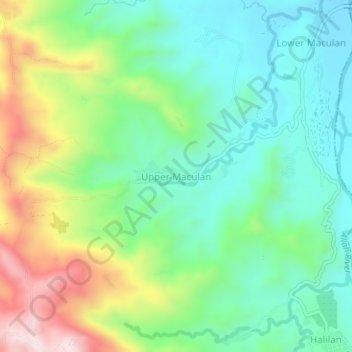
名称:Upper Maculan地形图、海拔、地势。
地点:Upper Maculan, South Cotabato, Soccsksargen, Philippines (6.22014 124.75298 6.26014 124.79298)
平均海拔:499 米
最低海拔:329 米
最高海拔:849 米
其他地形图
点击地图以查看其地形、其海拔和其地势。
Lake Sebu
The placid lake of Lake Sebu can be found in Allah Valley near the municipality of Surallah, South Cotabato. Surrounded by rolling hills and mountains covered with thick rain forest, the lake has an area of 361.124 hectares (892.36 acres), with an elevation of approximately 1,000 metres (3,300 ft).
平均海拔:710 米
Koronadal
The city's landscape features a combination of flatlands and gently sloping terrain, with approximately 50.18% of its total land area classified as predominantly flat. It is flanked by the Roxas and Quezon mountain ranges, whose elevations reach between 700 to 800 meters above sea level and gradually slope…
平均海拔:164 米
Lake Sebu
The placid lake of Lake Sebu can be found in Allah Valley near the municipality of Surallah, South Cotabato. Surrounded by rolling hills and mountains covered with thick rain forest, the lake has an area of 361.124 hectares (892.36 acres), with an elevation of approximately 1,000 metres (3,300 ft).
平均海拔:710 米