
Adichanallur地形图
点击地图以显示海拔。
关于这张地图
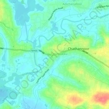
名称:Adichanallur地形图、海拔、地势。
地点:Adichanallur, Kollam, Kerala, 691573, India (8.84187 76.68528 8.88187 76.72528)
平均海拔:19 米
最低海拔:0 米
最高海拔:68 米
其他地形图
点击地图以查看其地形、其海拔和其地势。
Ashtamudi Lake
India > Kerala > Kollam > Kottayathukadavu
Ashtamudi Lake (Ashtamudi Kayal), in the Kollam District of the Indian state of Kerala, is the most visited backwater and lake in the state. It possesses a unique wetland ecosystem and a large palm-shaped (also described as octopus-shaped) water body, second only in size to the Vembanad estuary ecosystem of…
平均海拔:6 米