Guarnizo地形图
点击地图以显示海拔。
关于这张地图
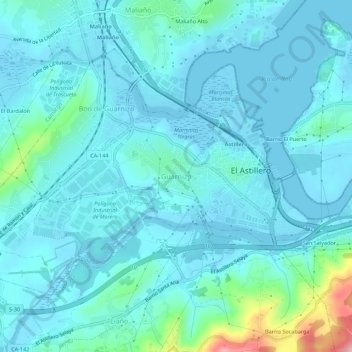
名称:Guarnizo地形图、海拔、地势。
地点:Guarnizo, El Astillero, Cantabria, 39611, España (43.37953 -3.85026 43.41953 -3.81026)
平均海拔:23 米
最低海拔:-5 米
最高海拔:176 米
其他地形图
点击地图以查看其地形、其海拔和其地势。

点击地图以显示海拔。
名称:Guarnizo地形图、海拔、地势。
地点:Guarnizo, El Astillero, Cantabria, 39611, España (43.37953 -3.85026 43.41953 -3.81026)
平均海拔:23 米
最低海拔:-5 米
最高海拔:176 米
点击地图以查看其地形、其海拔和其地势。