点击地图以显示海拔。
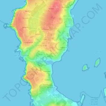
名称:Kerincuff地形图、海拔、地势。
地点:Kerincuff, Roscanvel, Châteaulin, Finistère, Bretagne, France métropolitaine, 29570, France (48.28873 -4.57544 48.32873 -4.53544)
平均海拔:17 米
最低海拔:-1 米
最高海拔:76 米
点击地图以查看其地形、其海拔和其地势。
France > Bretagne > Finistère > Roscanvel
平均海拔:13 米