
Saint Augustine地形图
点击地图以显示海拔。
关于这张地图
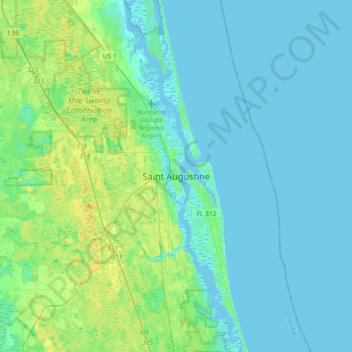
名称:Saint Augustine地形图、海拔、地势。
平均海拔:5 米
最低海拔:-5 米
最高海拔:21 米
其他地形图
点击地图以查看其地形、其海拔和其地势。
Saint Augustine
United States > Florida > Saint Johns County
Saint Augustine is characterized by a diverse topography that features a mix of coastal and inland landscapes. Situated along the eastern coast of the state, the city lies on a narrow peninsula bordered by the Atlantic Ocean to the east and the Matanzas River to the west. The area includes sandy beaches that…
平均海拔:5 米