点击地图以显示海拔。
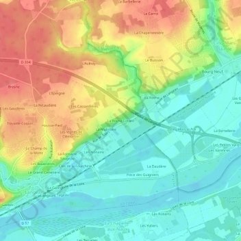
名称:La Roche Cotard地形图、海拔、地势。
地点:La Roche Cotard, Langeais, Chinon, Indre-et-Loire, Centre-Val de Loire, France métropolitaine, 37130, France (47.31578 0.40841 47.35578 0.44841)
平均海拔:62 米
最低海拔:32 米
最高海拔:105 米
点击地图以查看其地形、其海拔和其地势。
France > Centre-Val de Loire > Indre-et-Loire > Langeais
平均海拔:82 米
France > Centre-Val de Loire > Indre-et-Loire > Langeais > Beaumontais
平均海拔:88 米