
Layton地形图
点击地图以显示海拔。
关于这张地图
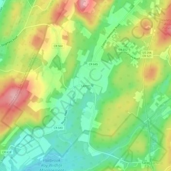
名称:Layton地形图、海拔、地势。
平均海拔:193 米
最低海拔:128 米
最高海拔:284 米
其他地形图
点击地图以查看其地形、其海拔和其地势。
Stokes State Forest
United States > New Jersey > Sussex County > Sandyston Township
The pavilion at the top of the peak makes a great place to picnic. To make traveling to Sunrise more interesting, one can look for the New Jersey shaped rock. The mountain is the second highest point in New Jersey, being 1,653 feet (504 m) above sea level. Hikers are amazed with the view. There is a USGS…
平均海拔:260 米