
Longonot地形图
点击地图以显示海拔。
Longonot
Mount Longonot is protected by Kenya Wildlife Service as part of Mount Longonot National Park. A 3.1 km trail runs from the park entrance up to the crater rim, and continues in a 7.2 km loop encircling the crater. The whole tour (gate-around the rim-gate) of 13.5 km takes about 4–5 hours allowing for necessary rest breaks - parts of the trail are heavily eroded and very steep. The gate elevation is around 2150 m and the peak at 2776 m but following the jagged rim involves substantially more than the 630 m vertical difference.
关于这张地图
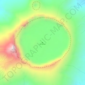
名称:Longonot地形图、海拔、地势。
地点:Longonot, Mai Mahiu ward, Naivasha, Nakuru, Rift Valley, Kenya (-0.91449 36.45641 -0.91439 36.45651)
平均海拔:2,439 米
最低海拔:2,210 米
最高海拔:2,758 米