
Bend地形图
点击地图以显示海拔。
Bend
The Deschutes River runs through Bend, where it is dammed to form Mirror Pond. Bend's elevation is 3,623 feet (1,104 metres) above sea level. The city has a total area of 33.27 square miles (86.17 square kilometres), of which 33.01 sq mi (85.50 km2) is land and 0.26 sq mi (0.67 km2) is water.
关于这张地图
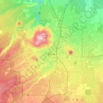
名称:Bend地形图、海拔、地势。
地点:Bend, Deschutes County, Oregon, United States (43.99906 -121.38243 44.12375 -121.24335)
平均海拔:1,121 米
最低海拔:985 米
最高海拔:1,286 米