
Ashland地形图
点击地图以显示海拔。
Ashland
According to the United States Census Bureau, the CDP has a total area of 1.8 square miles (4.7 km2), all of it land and sits at an elevation of 43 feet above sea level.
关于这张地图
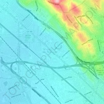
名称:Ashland地形图、海拔、地势。
地点:Ashland, Alameda County, California, 94580, United States (37.67465 -122.13385 37.71465 -122.09385)
平均海拔:38 米
最低海拔:3 米
最高海拔:185 米
其他地形图
点击地图以查看其地形、其海拔和其地势。
Lake Del Valle
United States > California > Alameda County
The dam is 230 feet (70 m) high and 880 feet (270 m) long. Its crest elevation is 773 feet (236 m). The dam contains 4,150,000 cubic yards (3,170,000 m3) of earth fill.
平均海拔:339 米
Dougherty Hills Open Space
United States > California > Alameda County > Dublin > Komandorski Village
平均海拔:120 米