Clarksburg地形图
点击地图以显示海拔。
关于这张地图
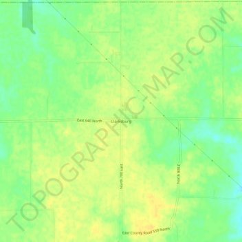
名称:Clarksburg地形图、海拔、地势。
地点:Clarksburg, Decatur County, Indiana, 47225, United States (39.41338 -85.36774 39.45338 -85.32774)
平均海拔:321 米
最低海拔:306 米
最高海拔:330 米
其他地形图
点击地图以查看其地形、其海拔和其地势。

点击地图以显示海拔。
名称:Clarksburg地形图、海拔、地势。
地点:Clarksburg, Decatur County, Indiana, 47225, United States (39.41338 -85.36774 39.45338 -85.32774)
平均海拔:321 米
最低海拔:306 米
最高海拔:330 米
点击地图以查看其地形、其海拔和其地势。