
Kurnool地形图
点击地图以显示海拔。
Kurnool
Kurnool is located at 15°50′00″N 78°03′00″E / 15.8333°N 78.05°E / 15.8333; 78.05. It has an average elevation of 273 metres (898 feet). Kurnool lies on the banks of the Tungabhadra River. The Hundri and Neeva rivers also flow through the city. The K.C.Canal (Kurnool–Cuddapah) was built by the Dutch for transportation, but later used for irrigation.
关于这张地图
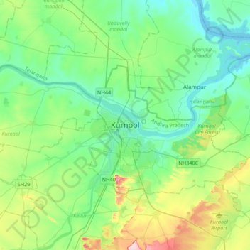
名称:Kurnool地形图、海拔、地势。
地点:Kurnool, Andhra Pradesh, 518001, India (15.67093 77.88254 15.99093 78.20254)
平均海拔:307 米
最低海拔:259 米
最高海拔:453 米