Beech Grove地形图
点击地图以显示海拔。
关于这张地图
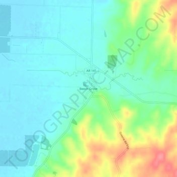
名称:Beech Grove地形图、海拔、地势。
地点:Beech Grove, Greene County, Arkansas, United States (36.15229 -90.63928 36.19229 -90.59928)
平均海拔:105 米
最低海拔:82 米
最高海拔:163 米
其他地形图
点击地图以查看其地形、其海拔和其地势。

点击地图以显示海拔。
名称:Beech Grove地形图、海拔、地势。
地点:Beech Grove, Greene County, Arkansas, United States (36.15229 -90.63928 36.19229 -90.59928)
平均海拔:105 米
最低海拔:82 米
最高海拔:163 米
点击地图以查看其地形、其海拔和其地势。