
Mollie Gap地形图
点击地图以显示海拔。
关于这张地图
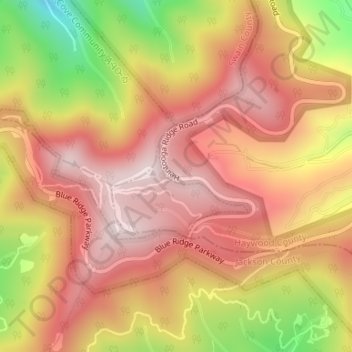
名称:Mollie Gap地形图、海拔、地势。
地点:Mollie Gap, Haywood County, North Carolina, United States (35.51505 -83.18020 35.51515 -83.18010)
平均海拔:1,464 米
最低海拔:1,135 米
最高海拔:1,655 米
其他地形图
点击地图以查看其地形、其海拔和其地势。
Waynesville
United States > North Carolina > Haywood County
Most of the town of Waynesville lies between 2,600 and 3,000 feet (790 and 910 m) above sea level, in a valley among 5,000-to-6,410-foot (1,520 to 1,950 m) mountain peaks. With the high Great Balsam Mountains to the west-southwest, and the Plott Balsams to the west-northwest, a handful of peaks over 6000' in…
平均海拔:921 米
Cataloochee Valley Viewpoint
United States > North Carolina > Haywood County > Cataloochee
平均海拔:1,058 米
Waynesville
United States > North Carolina > Haywood County
Most of the town of Waynesville lies between 2,600 and 3,000 feet (790 and 910 m) above sea level, in a valley among 5,000-to-6,410-foot (1,520 to 1,950 m) mountain peaks. With the high Great Balsam Mountains to the west-southwest, and the Plott Balsams to the west-northwest, a handful of peaks over 6000' in…
平均海拔:921 米