
Harley地形图
点击地图以显示海拔。
关于这张地图
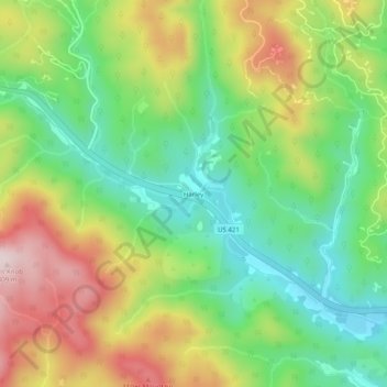
名称:Harley地形图、海拔、地势。
地点:Harley, Wilkes County, North Carolina, United States (36.17291 -81.43454 36.21291 -81.39454)
平均海拔:568 米
最低海拔:401 米
最高海拔:810 米
其他地形图
点击地图以查看其地形、其海拔和其地势。
Doughton Park
United States > North Carolina > Wilkes County
Doughton Park (Doughton Recreational Area) is the largest recreation area the National Park Service manages on the Blue Ridge Parkway. It is located between mile markers 238.5 - 244.7 on the border between Wilkes and Alleghany Counties in North Carolina. Doughton Park consists of highland meadows with numerous…
平均海拔:855 米
Stone Mountain State Park
United States > North Carolina > Wilkes County
The centerpiece of the park is Stone Mountain, a dome of exposed granite (specifically a quartz diorite to granodiorite) of Devonian age, which has intruded into the gneiss of the Precambrian Alligator Back Formation. It rises sharply over 600 feet (183 m) above the surrounding terrain. The mountain, which has…
平均海拔:641 米