
Creekside Village地形图
点击地图以显示海拔。
关于这张地图
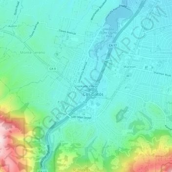
名称:Creekside Village地形图、海拔、地势。
平均海拔:166 米
最低海拔:79 米
最高海拔:486 米
其他地形图
点击地图以查看其地形、其海拔和其地势。
Vasona Lake County Park
United States > California > Santa Clara County > Los Gatos > Shannon
平均海拔:109 米
Lexington Reservoir County Park
United States > California > Santa Clara County > Los Gatos
The reservoir is in the foothills of the Santa Cruz Mountains, at an elevation of 645 feet (197 m).
平均海拔:330 米