
Forest Glade地形图
点击地图以显示海拔。
关于这张地图
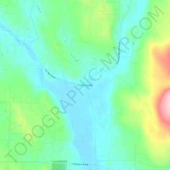
名称:Forest Glade地形图、海拔、地势。
地点:Forest Glade, Snohomish County, Washington, United States (47.96149 -121.99318 48.00149 -121.95318)
平均海拔:145 米
最低海拔:86 米
最高海拔:298 米
其他地形图
点击地图以查看其地形、其海拔和其地势。
Monroe
United States > Washington > Snohomish County
The city lies at the eastern end of the Snohomish River floodplain, with elevations that range from 40 to 210 feet (12 to 64 m). The south and east edges of the city along the Skykomish River are within a 100-year flood hazard zone and also include habitats for migratory birds and game animals. The residential…
平均海拔:49 米
Arlington
United States > Washington > Snohomish County
The city lies on a glacial terrace formed during the Pleistocene epoch by the recession of the Cordilleran Ice Sheet. Arlington covers a series of hills that sit at an elevation of 100 to 200 feet (30 to 61 m) above sea level. Downtown Arlington is situated on a bluff above the confluence of the Stillaguamish…
平均海拔:60 米
Marysville
United States > Washington > Snohomish County
The city's topography varies from the low-lying downtown, located along the banks of Ebey Slough 5 feet (1.5 m) above sea level, rising to 160 feet (49 m) near Smokey Point and over 465 feet (142 m) in the eastern highlands. Marysville sits in the watershed of two major creeks, Quilceda Creek and Allen Creek,…
平均海拔:72 米
Stanwood
United States > Washington > Snohomish County
The city is located at the mouth of the Stillaguamish River, where it flows into Port Susan, an arm of the Puget Sound, and Skagit Bay, the mouth of the Skagit River. To the west is Davis Slough, which separates Stanwood from Camano Island and forms the border between Snohomish and Island counties. Elevations…
平均海拔:20 米
Marysville
United States > Washington > Snohomish County
The city's topography varies from the low-lying downtown, located along the banks of Ebey Slough 5 feet (1.5 m) above sea level, rising to 160 feet (49 m) near Smokey Point and over 465 feet (142 m) in the eastern highlands. Marysville sits in the watershed of two major creeks, Quilceda Creek and Allen Creek,…
平均海拔:72 米
Mountlake Terrace
United States > Washington > Snohomish County
The city sits on a plateau that is elevated from the surrounding landscape, with views of the Olympic and Cascade mountains. The Mountlake Terrace's elevation ranges from 263 to 528 feet (80 to 161 m) above sea level, with an average altitude of 440 feet (130 m). The southwestern portion of the city includes…
平均海拔:121 米
Stanwood
United States > Washington > Snohomish County
The city is located at the mouth of the Stillaguamish River, where it flows into Port Susan, an arm of the Puget Sound, and Skagit Bay, the mouth of the Skagit River. To the west is Davis Slough, which separates Stanwood from Camano Island and forms the border between Snohomish and Island counties. Elevations…
平均海拔:20 米
Arlington
United States > Washington > Snohomish County
The city lies on a glacial terrace formed during the Pleistocene epoch by the recession of the Cordilleran Ice Sheet. Arlington covers a series of hills that sit at an elevation of 100 to 200 feet (30 to 61 m) above sea level. Downtown Arlington is situated on a bluff above the confluence of the Stillaguamish…
平均海拔:60 米
Mountlake Terrace
United States > Washington > Snohomish County
The city sits on a plateau that is elevated from the surrounding landscape, with views of the Olympic and Cascade mountains. The Mountlake Terrace's elevation ranges from 263 to 528 feet (80 to 161 m) above sea level, with an average altitude of 440 feet (130 m). The southwestern portion of the city includes…
平均海拔:121 米
Gold Bar
United States > Washington > Snohomish County
Gold Bar is known as a white-water rafting destination for those seeking to float the Skykomish River. One of the most popular low elevation hikes in the metro Seattle area, the trail to Wallace Falls, is located on the north margin of the city. More than 160,000 people visit Wallace Falls State Park annually.
平均海拔:67 米
Marysville
United States > Washington > Snohomish County
The city's topography varies from the low-lying downtown, located along the banks of Ebey Slough 5 feet (1.5 m) above sea level, rising to 160 feet (49 m) near Smokey Point and over 465 feet (142 m) in the eastern highlands. Marysville sits in the watershed of two major creeks, Quilceda Creek and Allen Creek,…
平均海拔:72 米
Monroe
United States > Washington > Snohomish County
The city lies at the eastern end of the Snohomish River floodplain, with elevations that range from 40 to 210 feet (12 to 64 m). The south and east edges of the city along the Skykomish River are within a 100-year flood hazard zone and also include habitats for migratory birds and game animals. The residential…
平均海拔:49 米