
Cape Lookout地形图
点击地图以显示海拔。
关于这张地图
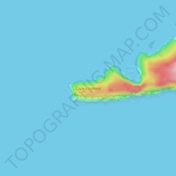
名称:Cape Lookout地形图、海拔、地势。
地点:Cape Lookout, Tillamook County, Oregon, United States (45.33873 -124.00417 45.33883 -124.00407)
平均海拔:11 米
最低海拔:0 米
最高海拔:200 米
其他地形图
点击地图以查看其地形、其海拔和其地势。
Nehalem
United States > Oregon > Tillamook County
Nehalem has an elevation of 11 feet. Lying so close to sea level, the area suffers intermittent floods. A 1996 storm caused particular damage, to local dairy farms. In November 2006, heavy rains caused flooding in Nehalem, resulting in $1 million in damage.
平均海拔:16 米