
Mount Vernon地形图
点击地图以显示海拔。
关于这张地图
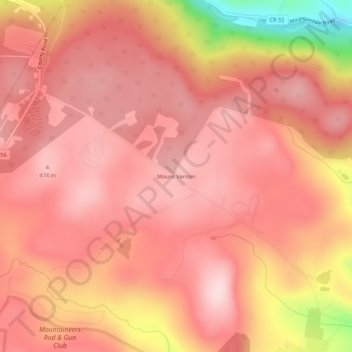
名称:Mount Vernon地形图、海拔、地势。
平均海拔:416 米
最低海拔:218 米
最高海拔:484 米
其他地形图
点击地图以查看其地形、其海拔和其地势。
Grahamsville
United States > New York > Sullivan County > Town of Neversink
Grahamsville is located at latitude 41.848 and longitude -74.548. The elevation is 968 feet. Grahamsville is in the Eastern Time Zone.
平均海拔:397 米
Village of Wurtsboro
United States > New York > Sullivan County
Wurtsboro is in the Eastern Time Zone. Its elevation is 577 feet.
平均海拔:204 米
Mountain Dale
United States > New York > Sullivan County > Town of Fallsburg
Mountaindale is a hamlet (and census-designated place) in the town of Fallsburg in Sullivan County, New York, United States, situated at an altitude of 1,010 feet (310 m).
平均海拔:363 米
Grahamsville
United States > New York > Sullivan County > Town of Neversink
Grahamsville is located at latitude 41.848 and longitude -74.548. The elevation is 968 feet. Grahamsville is in the Eastern Time Zone.
平均海拔:397 米
Town of Lumberland
United States > New York > Sullivan County
Lumberland is located within the Upper Delaware Scenic and Recreational River. Elevations range from approximately 600 feet near the Delaware River to over 1,300 feet above sea level on the bluffs overlooking the Delaware, and where the Catskill Mountains begin to rise in the northern reaches of the town. The…
平均海拔:360 米