
Mount Makalu地形图
点击地图以显示海拔。
Mount Makalu
Makalu (Nepali: मकालु हिमाल, romanized: Makālu himāl; Chinese: 马卡鲁峰; pinyin: Mǎkǎlǔ Fēng) is the fifth-highest mountain on Earth, with a summit at an elevation of 8,485 metres (27,838 ft) AMSL. It is located in the Mahalangur Himalayas 19 km (12 mi) southeast of Mount Everest, on the China–Nepal border. One of the eight-thousanders, Makalu is an isolated peak shaped like a four-sided pyramid.
关于这张地图
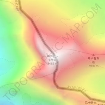
名称:Mount Makalu地形图、海拔、地势。
平均海拔:7,479 米
最低海拔:6,303 米
最高海拔:8,389 米
其他地形图
点击地图以查看其地形、其海拔和其地势。
Shelkar
China > Tibet > Tingri County
The town lies 7 kilometres (4.3 mi) off the Friendship Highway between Lhatse and Tingri, at an altitude of about 4,300 metres (14,100 ft), at the southern foot of 5,260 metres (17,260 ft) high Gyatso La. It is approximately 60 kilometres (37 mi) north-west of Mount Everest and just over 50 kilometres (31 mi)…
平均海拔:4,831 米