
Bakony地形图
点击地图以显示海拔。
关于这张地图
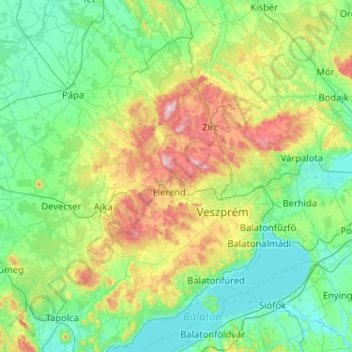
名称:Bakony地形图、海拔、地势。
地点:Bakony, Transdanubia, Hungary (46.89688 17.26855 47.42810 18.29849)
平均海拔:218 米
最低海拔:98 米
最高海拔:690 米
其他地形图
点击地图以查看其地形、其海拔和其地势。
Budapest
The wide Danube was always fordable at this point because of a small number of islands in the middle of the river. The city has marked topographical contrasts: Buda is built on the higher river terraces and hills of the western side, while the considerably larger Pest spreads out on a flat and featureless sand…
平均海拔:153 米
Budapest
The wide Danube was always fordable at this point because of a small number of islands in the middle of the river. The city has marked topographical contrasts: Buda is built on the higher river terraces and hills of the western side, while the considerably larger Pest spreads out on a flat and featureless sand…
平均海拔:171 米
Budapest
The wide Danube was always fordable at this point because of a small number of islands in the middle of the river. The city has marked topographical contrasts: Buda is built on the higher river terraces and hills of the western side, while the considerably larger Pest spreads out on a flat and featureless sand…
平均海拔:153 米
Pécs
Pécs is bordered by plains to the south (elevation 120–130 m), while the Mecsek mountains rise up to elevations of 400–600 meters behind the city. Jakab-hill, located in the western Mecsek, is 592 m (1942 ft) tall, Tubes, straight above Pécs, is 612 m (2008 ft) tall, and Misina is 535 m (1755 ft) tall.…
平均海拔:232 米
Kecskemét
Kecskemét was established at the meeting point of a large sandy region and a sandy yellow soil; its elevation is 120 m (394 ft) above sea level. The territory west of the city is covered by wind-blown sand, characterised by the almost parallel northern-southern sand dunes and the plain between them. At the…
平均海拔:116 米
Budapest
The wide Danube was always fordable at this point because of a small number of islands in the middle of the river. The city has marked topographical contrasts: Buda is built on the higher river terraces and hills of the western side, while the considerably larger Pest spreads out on a flat and featureless sand…
平均海拔:171 米
Budapest
The wide Danube was always fordable at this point because of a small number of islands in the middle of the river. The city has marked topographical contrasts: Buda is built on the higher river terraces and hills of the western side, while the considerably larger Pest spreads out on a flat and featureless sand…
平均海拔:171 米
Pécs
Pécs is bordered by plains to the south (elevation 120–130 m), while the Mecsek mountains rise up to elevations of 400–600 meters behind the city. Jakab-hill, located in the western Mecsek, is 592 m (1942 ft) tall, Tubes, straight above Pécs, is 612 m (2008 ft) tall, and Misina is 535 m (1755 ft) tall.…
平均海拔:232 米