
Antelao地形图
点击地图以显示海拔。
关于这张地图
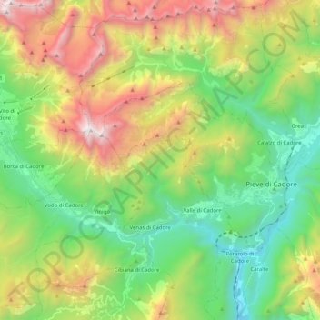
名称:Antelao地形图、海拔、地势。
地点:Antelao, Belluno, Veneto, Italia (46.39649 12.20010 46.48126 12.40120)
平均海拔:1,482 米
最低海拔:507 米
最高海拔:3,187 米
其他地形图
点击地图以查看其地形、其海拔和其地势。
Taibon Agordino
Taibon Agordino è situato nel fondovalle delle Dolomiti Agordine ad un'altitudine di 628 m s.l.m. nel punto dove il torrente Tegnas confluisce nel torrente Cordevole.
平均海拔:1,450 米
Sovramonte
Al centro dell'altopiano di Sovramonte, è ubicata una delle risorse agricole fondamentali di esso: la Campagna. È un'area pianeggiante di circa 30 ettari, a 600 metri d'altitudine: un bacino agricolo secolarmente utilizzato per la coltivazione di patate e fagioli, una sorta di serbatoio alimentare primario…
平均海拔:1,069 米
Selva di Cadore
A partire dal XIV secolo alle attività agro-silvo-pastorali si aggiunsero le attività artigianali e "industriali". Si cominciò a sfruttare le miniere del Fursil nel vicino territorio di Colle Santa Lucia. Queste attività comportarono una notevole immigrazione e l'avvio di nuove attività come i carbonai e…
平均海拔:1,852 米
Pocol
Italia > Veneto > Belluno > Cortina d'Ampezzo
Pocol (Pocòl in ladino) è una piccola località facente parte del comune di Cortina d'Ampezzo, in provincia di Belluno. L'altitudine media è di 1.527 m.
平均海拔:1,448 米
Gosaldo
Peculiarità del comune è la presenza di decine di borgatelle (qualcuno ne ha contate novantanove) gravitanti attorno ai due centri più importanti, Don (sede comunale) e Tiser. Questi agglomerati hanno dimensioni molto modeste e sono sorti un po' ovunque tra i 500 e i 1000 m di altitudine, preferibilmente…
平均海拔:1,433 米
Sovramonte
Al centro dell'altopiano di Sovramonte, è ubicata una delle risorse agricole fondamentali di esso: la Campagna. È un'area pianeggiante di circa 30 ettari, a 600 metri d'altitudine: un bacino agricolo secolarmente utilizzato per la coltivazione di patate e fagioli, una sorta di serbatoio alimentare primario…
平均海拔:1,069 米
Spert
Italia > Veneto > Belluno > Farra d'Alpago
Il centro è situato a 6 km in direzione sud-est rispetto al maggiore centro di Farra d'Alpago, ad un'altitudine di 923 m sul livello del mare. Essendo l'abitato più vicino alla foresta del Cansiglio, Spert è considerata la "Porta del Cansiglio".
平均海拔:914 米