
Coast Range地形图
点击地图以显示海拔。
关于这张地图
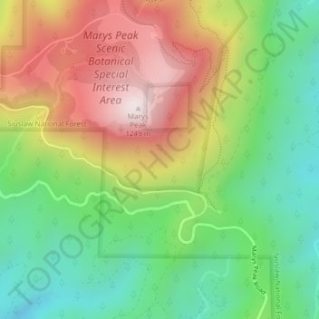
名称:Coast Range地形图、海拔、地势。
地点:Coast Range, Benton County, Oregon, United States (44.49995 -123.55005 44.50005 -123.54995)
平均海拔:824 米
最低海拔:508 米
最高海拔:1,245 米
其他地形图
点击地图以查看其地形、其海拔和其地势。
Corvallis
United States > Oregon > Benton County
Corvallis is at an elevation of 235 feet (72 m) above sea level. Situated midway in the Willamette Valley, in terms of driving distances, Corvallis is about 46 miles (74 km) east of Newport and the Oregon Coast, 85 miles (137 km) south of Portland, 30 miles (48 km) south of the state capital, Salem, 10 miles…
平均海拔:81 米