点击地图以显示海拔。
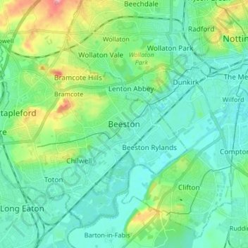
名称:Beeston地形图、海拔、地势。
地点:Beeston, Broxtowe, Nottinghamshire, East Midlands, England, NG9 2JJ, United Kingdom (52.88572 -1.25619 52.96572 -1.17619)
平均海拔:44 米
最低海拔:20 米
最高海拔:122 米
点击地图以查看其地形、其海拔和其地势。
United Kingdom > England > Nottinghamshire > Broxtowe > Beeston
平均海拔:34 米
United Kingdom > England > Nottinghamshire > Broxtowe
平均海拔:54 米
平均海拔:104 米
United Kingdom > England > Nottinghamshire > Broxtowe > Newthorpe
平均海拔:81 米
平均海拔:62 米
平均海拔:100 米
平均海拔:39 米
United Kingdom > England > Nottinghamshire > Broxtowe > Bramcote
平均海拔:57 米
平均海拔:68 米
平均海拔:95 米
平均海拔:66 米
United Kingdom > England > Nottinghamshire > Broxtowe > Strelley
平均海拔:70 米